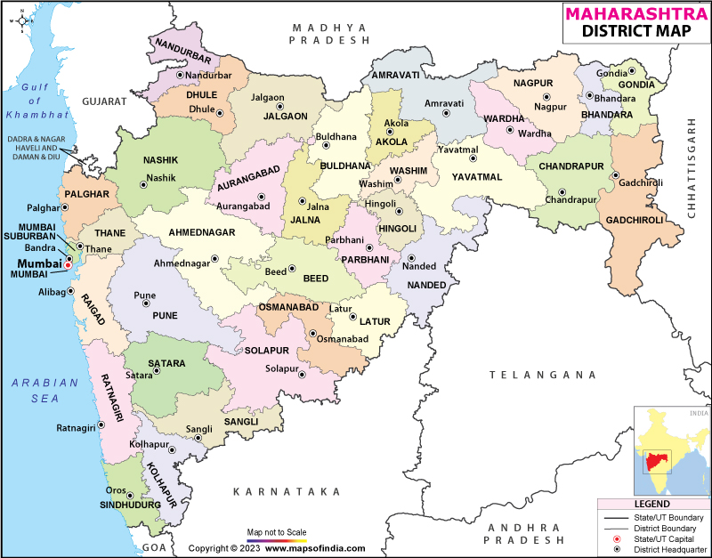
Maharashtra, located in Western India is one of the country's wealthiest states and contributes around 15% of the countries industrial output (2006-07 figures).
The state covers an area of 307,731 km square and has a population of 112,372, 972 (2011 census). Mumbai is the capital of
Maharashtra and is also the largest city and financial capital of India. It's neighbouring states are
Madhya Pradesh ,
Chhattisgarh , Karnataka, Andhra Pradesh. Nagpur and
Pune are other important cities in the state. Marathi is the official language of Maharashtra.
Maharashtra is divided into 35 districts and 6 administrative divisions, namely; Mumbai (Konkan), Nashik, Aurangabad, Amravali and Nagpur. The 35 districts are divided into 109 sub-divisions and 357 taluks.
Famous tourist destinations in Maharashtra include the capital city of Mumbai, which is also known as the New York City/Los Angeles of the East and is popular for the Hindi film industry, Bollywood. This buzzing city has many tourist attractions such as the Gateway of India, Bandra-Worli Sea link, Juhu Beach and the Chatrapati Shivaji Terminus among others. Aurangabad, also known as the tourism capital of Maharashtra is known for its ancient Ajanta and Ellora caves, Nagpur is known for producing some of India's finest oranges, Nashik is known for its temples and Ratnagiri by the coast is famous for its delicious mangoes.
List of Districts in Maharashtra
| sno | District | Headquarters | Population | Sex Ratio (per 1000) | Average Literacy |
|---|
| 1 | Ahmednagar | Ahmednagar | 4,543,159 | 939 | 79.05% |
| 2 | Akola | Akola | 1,813,906 | 946 | 88.05% |
| 3 | Amravati | Amravati | 2,888,445 | 951 | 87.38% |
| 4 | Aurangabad | Aurangabad | 3,701,282 | 923 | 79.02% |
| 5 | Beed | Beed | 2,585,049 | 916 | 76.99% |
| 6 | Bhandara | Bhandara | 1,200,334 | 982 | 83.76% |
| 7 | Buldhana | Buldhana | 2,586,258 | 934 | 83.4% |
| 8 | Chandrapur | Chandrapur | 2,204,307 | 961 | 80.01% |
| 9 | Dhule | Dhule | 2,050,862 | 946 | 72.8% |
| 10 | Gadchiroli | Gadchiroli | 1,072,942 | 982 | 74.36% |
| 11 | Gondia | Gondia | 1,322,507 | 999 | 84.95% |
| 12 | Hingoli | Hingoli | 1,177,345 | 942 | 78.17% |
| 13 | Jalgaon | Jalgaon | 4,229,917 | 925 | 78.2% |
| 14 | Jalna | Jalna | 1,959,046 | 937 | 71.52% |
| 15 | Kolhapur | Kolhapur | 3,876,001 | 957 | 81.51% |
| 16 | Latur | Latur | 2,454,196 | 928 | 77.26% |
| 17 | Mumbai City | - | 3,085,411 | 832 | 89.21% |
| 18 | Mumbai Suburban | Bandra (East) | 9,356,962 | 860 | 89.91% |
| 19 | Nagpur | Nagpur | 4,653,570 | 951 | 88.39% |
| 20 | Nanded | Nanded | 3,361,292 | 943 | 75.45% |
| 21 | Nandurbar | Nandurbar | 1,648,295 | 978 | 64.38% |
| 22 | Nashik | Nashik | 6,107,187 | 934 | 82.31% |
| 23 | Osmanabad | Osmanabad | 1,657,576 | 924 | 78.44% |
| 24 | Parbhani | Parbhani | 1,836,086 | 947 | 73.34% |
| 25 | Pune | Pune | 9,429,408 | 915 | 86.15% |
| 26 | Raigad | Alibag | 2,634,200 | 959 | 83.14% |
| 27 | Ratnagiri | Ratnagiri | 1,615,069 | 1122 | 82.18% |
| 28 | Sangli | Sangli | 2,822,143 | 966 | 81.48% |
| 29 | Satara | Satara | 3,003,741 | 988 | 82.87% |
| 30 | Sindhudurg | Oros | 849,651 | 1036 | 85.56% |
| 31 | Solapur | Solapur | 4,317,756 | 938 | 77.02% |
| 32 | Thane | Thane | 11,060,148 | 886 | 84.53% |
| 33 | Wardha | Wardha | 1,300,774 | 946 | 86.99% |
| 34 | Washim | Washim | 1,197,160 | 930 | 83.25% |
| 35 | Yavatmal | Yavatmal | 2,772,348 | 952 | 82.82% |
District Administration in Maharashtra: Each district of Maharashtra is headed by a Deputy Commissioner who is in charge of the administration of that particular district. Being the highest administrative authority, the Deputy Commissioner has to carry out various disciplinary responsibilities as Deputy Commissioner, District Magistrate and Collector.
As a Deputy Commissioner he is in charge of the overall functioning of the district, as a District Magistrate he oversees the law and order condition and as a Collector he is responsible for revenue collection and recovery.


No comments:
Post a Comment